


rouelle Daniel

doboul
User
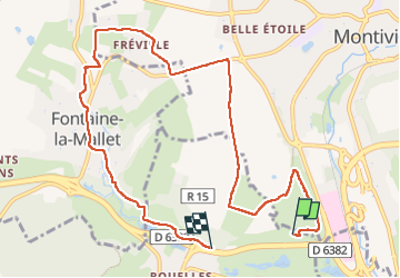

Length
9.4 km

Max alt
82 m

Uphill gradient
121 m
Km-Effort
11 km

Min alt
16 m

Downhill gradient
133 m
Boucle
No
Creation date :
2022-10-17 07:28:42.224
Updated on :
2022-10-17 09:57:09.825
2h17
Difficulty : Medium

FREE GPS app for hiking
 SityTrail
IGN / Geographical institutes
SityTrail Plus
The world is yours!
About
Trail Walking of 9.4 km to be discovered at Normandy, Seine-Maritime, Le Havre. This trail is proposed by doboul.
Description
Rando le 17 10
Positioning
Country:
France
Region :
Normandy
Department/Province :
Seine-Maritime
Municipality :
Le Havre
Location:
Unknown
Start:(Dec)
Start:(UTM)
295770 ; 5489728 (31U) N.
Comments